This is the first part of a trip report of the climb of Mulhacén, the highest mountain of continental Spain. I started in the small mountain village of Capileira and reached the mountain hut Poquiera.

Trip Overview
- Name: Mulhacén
- Height: 3482 m
- Prominence: 3285 m
- Location: Sierra Nevada, Andalucía, Spain
- Date: April 2012
- Conditions: mild winter
- Route: Up: West, Down: South (see text)
I did the trip in late April 2012, when the mountain was still mostly in winter conditions. The trip report is spread over two blog posts because of its length. In this first post, I will describe the first day of the ascent, the journey from the village of Capileira to the Refugio Poquiera.
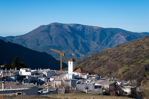
After a few weeks of heavy snowfall in the Spanish Sierra Nevada, it was not clear if the ascent to the highest mountain of the Spanish mainland, the Mulhacén, would be possible at all in the time slot available. Luckily after spending a couple of extra days in the beautiful city of Granada and checking the mountain weather forecast regularly, roughly a week of good and stable weather was predicted. So I headed into the Alpujarras, which is a region South of Granada and South of the Sierra Nevada in Andalucía. It lies mainly in the province of Granada but stretches as far as Almería in the very East. The region consists mostly of tiny towns built into the slopes of the mountains. Most of the houses are painted white to reflect the sun light better and keep the interior as cool as possible. This gives the towns their characteristic appearance as white villages.
First I headed to the town of Trevélez, which is known for its jamón de Trevélez, a delicious type of ham that the town is famous for. It is also the highest village in the Alpujarras at an altitude of about 1476 meters. I spent a day there and did a few trips in the mountains. This included an ascent to the Laguna del Goterón, which is a small lake located below the peak of Alcazaba (3371 m), which in turn is the third highest peak in the Sierra Nevada after Mulhacén and Veleta. I also did a short trip to the Siete Lagunas. These are seven small natural ponds filled with water from the mountains, that are nicely located at a quite flat part at the slope of the mountain on very fertile meadows.
To the Refugio Poquiera
From the campsite in Trevélez, I had to take the first bus of the day, shortly after 06:00 early in the morning to reach the starting point for the ascent to Mulhacén. I had to get up before 05:00, get ready and pack all the equipment needed for the trip, all only in the light of my headlamp. Then I headed down the road towards Trevélez, where I stood in the dark for a while and waited for the bus.
It took me to Capileira, which is situated on the opposite slope of the mountain compared to Trevélez. As it was still quite dark and cold, I waited roughly an hour for the sun to shine into the valley and had breakfast. Around 09:00, and a bit later than I had hoped, I started the ascent towards Refugio Poquiera, which is a mountain hut situated at around 2500 m, directly below the peaks of Mulhacén and Veleta.

I took the trail that leads through the Poquiera valley up the mountain, as this path seemed to offer the best views of the mountain panorama. The first part of the trail was quite level and unexpectedly easy, so I could walk relatively fast until La Cebadilla, which is a long abandoned and tiny settlement of workers who constructed the water system that supports Capileira. A few hundred meters uphill there is a hydrodynamic plant which delivers the electric power for Capileira and a few neighbouring towns.

Unfortunately, from there the easy trail that follows along Río Poquiera and that I had planned to take was out of service. So I had to take a much harder one which led along one of the lower ridges higher and higher into the Sierra Nevada massif. By that time it was around 13:00 and I was delighted that I had taken enough water with me, as the sun was burning heavily and there was practically no shade.
Slowly the trail led up the slope and out of the Poquiera valley. When I came out of the valley, using the telephoto lens on my camera, I could see a building in the distance and I was thrilled that it might be the Refugio. However, as I drew nearer, I could see that it was destroyed more or less completely.
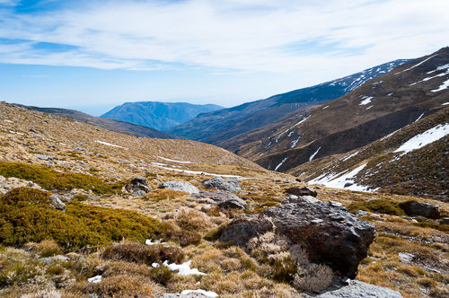
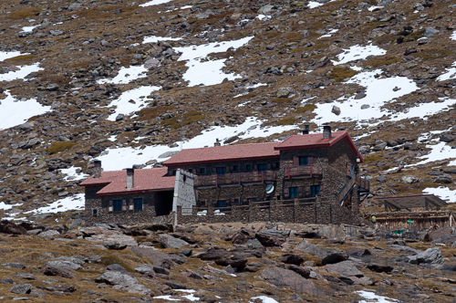
When I ascended further, the number of snowfields increased, and they often covered the trail. I encountered a group of three, probably French guys who were taking a rest near a steeper part of the path that was entirely covered with snow. Most of them were only wearing light sport shoes. After a short conversation, the group descended again. They did not dare to walk through the snow with their shoes. As this part of the trail was quite steep and I did not want to risk to slide down the slope in the snowfield, I took a small detour and scrambled over some rocks uphill. The last part of the trail to the Refugio was marked with long red plastic poles which were attached to strong metal bolts which in turn were firmly anchored into the ground so that the path was still visible under a lot of snow. After quite a bit more scrambling I could finally see the Refugio in the distance. This last part took me around an hour, much more time than expected. The whole ascent from Capileira to the Refugio took me roughly five hours, with a lot of picture taking included.

At this point, I checked in at the Refugio, rented crampons and rested a little. When I sat outside in front of the building, I could see many mountain goats only a short distance away. They were naturally accustomed to people staying at the hut. In the afternoon I scouted the first part of the route up to Mulhacén to investigate the best path and the general conditions of the route.
In the evening we had dinner in the Refugio. Although many different courses were served, I cannot recommend the meal. Nonetheless, it was filling and more than adequate for the great efforts that would come the next day. The Refugio is mainly unheated, so it gets really cold in there after sunset. The only place that is heated is the dining room, where all the people gathered around the fireplace after dinner. The beds are simple mattresses with roughly shoulder width arranged in two stories. If the Refugio were booked out entirely, you would lie shoulder to shoulder with your neighbours, but as it was nearly empty I had a whole story for myself! A few blankets were provided, but in addition to that, I slept almost fully clothed. That was OK for me, but if you get cold easily, make sure to bring a sleeping bag!
The second part is now online as well.